Log in
All resources
Create a design
9,296 Free Artworks of Map Collection
bibliothèque nationale de france
copper engraving print
british library
joan blaeu
atlas maior, vol 5 (england) - joan blaeu, 1667 - bl 114.h(star).5
maps of spain by tomas lopez
eran laor cartographic collection
drawings in the museu antônio parreiras
map - museu antônio parreiras
antônio parreiras
eran laor cartographic collection
tranquillo mollo
eran laor cartographic collection
giovanni antonio magini
eran laor cartographic collection
giovanni maria cassini
maps of the dutch east india company - india
1705
maps of the west-indische compagnie
1705
1574 maps of africa
1570s maps of egypt
lawrence h. slaughter collection of english maps, charts, globes, books and atlases
de nieuwe en onbekende weereld
eran laor cartographic collection
baroque
turgot map of paris, david rumsey historical map collection – derivative files
reuilly (paris)
maps by guillaume sanson
maps of galatia
panoramic maps of seville by braun & hogenberg
maps of cadiz by braun & hogenberg
a map of the british empire in america with the french and spanish settlements adjacent thereto
1730s maps of the caribbean
maps of the west-indische compagnie
1665
coats of arms of perpignan
baroque painting,baroque
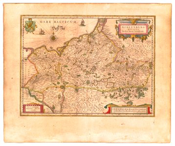
old maps of mecklenburg
powell library
1779 maps of new york (state)
old maps of new york (state)
atlas minor gerardi mercatoris (1621, maps)
maps of china by mercator-hondius
maps by hendrik hondius the younger
maps from gallica
maps of the kingdom of valencia
1762 maps of spain
maps of spain by tomas lopez
1783 maps of spain
maps of spain by tomas lopez
1783 maps of spain
maps of spain by tomas lopez
1774 maps of spain
maps of spain by tomas lopez
1774 maps of spain
atlas maior, vol 6 (scotland and ireland) - joan blaeu, 1667 - bl 114.h(star).6
1667 maps
1770s maps of algeria
maps by tomas lopez
maps of spain by tomas lopez
1783 maps of spain
maps of spain by tomas lopez
1783 maps of spain
pedro murillo velarde
baroque painting
maps of the kingdom of valencia
1762 maps of spain
maps of spain by tomas lopez
1774 maps of spain
maps of spain by tomas lopez
1774 maps of spain
old county maps of hertfordshire
maps by thomas kitchin
william henry toms
henry popple
eran laor cartographic collection
richard william seale
eran laor cartographic collection
bolognino zaltieri
georg balthasar probst (1732-1801)
eran laor cartographic collection
eran laor cartographic collection
richard william seale
eran laor cartographic collection
willem albert bachiene
1700s maps of the tsardom of russia
1700s maps of eastern europe
maps of ancient israel by philippe de la rué
old maps of ancient israel
atlas maior, vol 5 (england) - joan blaeu, 1667 - bl 114.h(star).5
17th-century maps of cheshire
atlas maior, vol 5 (england) - joan blaeu, 1667 - bl 114.h(star).5
17th-century maps of cumberland
atlas maior, vol 5 (england) - joan blaeu, 1667 - bl 114.h(star).5
17th-century maps of gloucestershire
atlas maior, vol 3 (germany) - joan blaeu, 1667 - bl 114.h(star).3
17th-century maps of silesia
atlas maior, vol 5 (england) - joan blaeu, 1667 - bl 114.h(star).5
17th-century maps of wiltshire
atlas maior, vol 5 (england) - joan blaeu, 1667 - bl 114.h(star).5
17th-century maps of cardiganshire
atlas maior, vol 5 (england) - joan blaeu, 1667 - bl 114.h(star).5
17th-century maps of surrey
atlas maior, vol 7 (france i) - joan blaeu, 1667 - bl 114.h(star).7
1667 maps
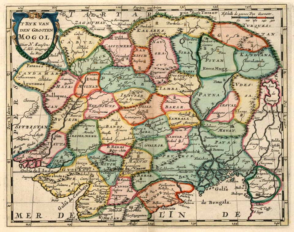
atlas maior, vol 11 (asia) - joan blaeu, 1667 - bl 114.h(star).11
1667 maps
atlas maior, vol 5 (england) - joan blaeu, 1667 - bl 114.h(star).5
17th-century maps of hampshire
atlas maior, vol 5 (england) - joan blaeu, 1667 - bl 114.h(star).5
17th-century maps of suffolk
atlas maior, vol 9 (italy) - joan blaeu, 1667 - bl 114.h(star).9
1667 maps of italy
atlas maior, vol 5 (england) - joan blaeu, 1667 - bl 114.h(star).5
17th-century maps of berkshire
atlas maior, vol 12 (america) - joan blaeu, 1667 - bl 114.h(star).12
1667 maps
atlas maior, vol 9 (italy) - joan blaeu, 1667 - bl 114.h(star).9
1667 maps of italy
atlas maior, vol 6 (scotland and ireland) - joan blaeu, 1667 - bl 114.h(star).6
1667 maps
atlas maior, vol 6 (scotland and ireland) - joan blaeu, 1667 - bl 114.h(star).6
1667 maps
atlas maior, vol 5 (england) - joan blaeu, 1667 - bl 114.h(star).5
17th-century maps of kent
atlas maior, vol 5 (england) - joan blaeu, 1667 - bl 114.h(star).5
17th-century maps of cornwall
atlas maior, vol 5 (england) - joan blaeu, 1667 - bl 114.h(star).5
17th-century maps of sussex
atlas maior, vol 9 (italy) - joan blaeu, 1667 - bl 114.h(star).9
1667 maps of italy
atlas maior, vol 5 (england) - joan blaeu, 1667 - bl 114.h(star).5
17th-century maps of county durham
atlas maior, vol 5 (england) - joan blaeu, 1667 - bl 114.h(star).5
17th-century maps of devon
atlas maior, vol 5 (england) - joan blaeu, 1667 - bl 114.h(star).5
17th-century maps of dorset
atlas maior, vol 5 (england) - joan blaeu, 1667 - bl 114.h(star).5
17th-century maps of norfolk, england
19th century maps of haute-vienne
coats of arms of haute-vienne
coats of arms of nîmes
baroque
coats of arms of chalon-sur-saône
alphonse de lamartine
coats of arms of saint-brieuc
old maps of côtes-d'armor
19th-century maps of indre-et-loire
coats of arms of tours
victor levasseur - maps of france
pierre-jean david
den danske hærs historie til nutiden og den norske hærs historie indtil 1814
maps from the mechanical curator collection
glaciers and glaciation (1910)
maps of glaciers of alaska
media contributed by university of illinois urbana-champaign university library
renaissance
atlas ou representation du monde universel t. 2 (1633)
old maps of the republic of genoa
civitates orbis terrarum. de praecipuis totius universi urbibus. liber secundus
maps of neuss by braun & hogenberg
atlas ou representation du monde universel t. 2 (1633)
maps by hendrik hondius the younger
civitates orbis terrarum. de praecipuis totius universi urbibus. liber secundus
maps of kleve by braun & hogenberg
civitates orbis terrarum. de praecipuis totius universi urbibus. liber secundus
maps of wissembourg by braun & hogenberg
old maps of the dutch east india company
1747 maps of asia
maps of the west-indische compagnie
1747 maps of africa
old maps of the dutch east india company
1705
maps of arnhem by braun & hogenberg
maps of venlo by braun & hogenberg
old maps of the northern hemisphere
old maps of the arctic
arnold van langren map of southwest africa
renaissance
drawings in the museu antônio parreiras
paper and graphite
drawings in the museu antônio parreiras
paper and graphite
maps by jacques chiquet
1719 maps of africa
drawings in the museu antônio parreiras
paper and graphite
drawings in the museu antônio parreiras
paper and charcoal
old maps of capitanata
puglia settentrionale
reconstructions of old maps
german renaissance
drawings in the museu antônio parreiras
paper and graphite
reconstructions of old maps
german renaissance
maps in the staats- und universitätsbibliothek hamburg
1870 maps of hamburg
drawings in the museu antônio parreiras
paper and charcoal
atlas geographico del reyno de españa e islas adjacentes (1757)
1757 maps of spain
drawings in the museu antônio parreiras
paper and graphite
drawings in the museu antônio parreiras
paper and graphite
maps of the dutch east india company - sri lanka
1787
2401 - 2500 of 9,296
Next page
/ 93